ARFI-RAWEX
Regional Aerosol Warming Experiment (RAWEX) aims at the following:
- Quantification of regional atmospheric warming by elevated aerosol over the Indian region, their amplitude, frequency of occurrence, seasonal trends.
- To quantify the contribution of absorbing aerosols (dust and BC) in the regional warming and to delineate the share of long-range transport and local contributions to the warming.
- Estimation of the radiative impact of these elevated aerosol layers using multi-layer radiative transfer calculations and then assess the climate implications
- Modeling of the impact of elevated aerosols on the regional climate.
High altitude Balloon Experiment
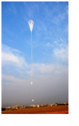
The high altitude balloon measurements of the vertical profiles of the mass concentration of aerosol black carbon (BC) concurrently with the atmospheric thermodynamics were conducted over the central Indian landmasses. The experiment put evidence of atmospheric warming due to elevated BC layers resulting in decrease in environmental lapse rate and increase in atmospheric stability, thus further trapping BC aerosols.
RAWEX Aircraft Experiments
To realise the RAWEX objectives, airborne measurements of vertical profiles of aerosols over the Indian mainland were conducted in two phases. The first phase of the experiment was during the winter season (Nov-Dec, 2012) when the aerosols have a longer lifetime, confined by the shallow winter atmospheric boundary layer and the atmosphere is dry with weak to moderate thermal convection. The second phase of the experiment was conducted during the pre-monsoon (Apr-May, 2013) season when solar heating is high enabling strong convection and vertical transport of aerosols to the higher altitude. More recently, during summer, 2016 another round of aircraft based observations have been carried out.
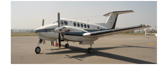
The experiment was carried out on board a twin-turbo propeller aircraft, Super King Beech craft 200 of National Remote Sensing Centre, Hyderabad. Measurements included vertical profiling up to an altitude of ~3000m AGL over the respective regions and the horizontal flights at 1500/ 3000m AGL connecting the base stations measuring spatial gradients. The total number of sorties, including the gradient sorties connecting the base of aircraft operations, is 62 and the total flying time during the experiment was ~ 200 hours, with a data collection of ~ 100%.
Measurements employed a suite of instruments: Aethalometer, Nephalometer, Aerodynamic Particle sizer, Optical Particle Counter, Photoacoustic soot spectrometer and dust track over distinct geographical environments.